Now, to take a step back. GeoGratis is the website run by Natural Resources Canada where one can download a whole host of maps and stuff geographical in nature. From the GeoGratis web site:
Most of the stuff there I haven't even a clue what it is (they list 81 different collections), but there are a couple of interest to me including the Atlas of Canada and, especially, the CanMatrix collection.Geospatial data available online at no cost and without restrictions!
GeoGratis is a portal provided by the Earth Sciences Sector (ESS) of Natural Resources Canada (NRCan) which provides geospatial data at no cost and without restrictions via your Web browser.
The data will be useful whether you're a novice who needs a geographic map for a presentation, or an expert who wants to overlay a vector layer of digital data on a classified multiband image, with a digital elevation model as a backdrop.
The geospatial data are grouped in collections and are compatible with the most popular geographic information systems (GIS), with image analysis systems and the graphics applications of editing software.
However, I accidentally clicked on the CanTopo collection rather than CanMatrix. In doing so, I learned something interesting and "discovered" CanTopo:
AbstractExciting stuff! Currently, only some areas in southern B.C. are available and I eagerly await them spreading across the country. The maps are downloadable as .tif or .pdf files. I had a look at the maps to see how these new versions compare. See for yourself as I did some screen captures from a map near Hope, B.C. and added them here. The tif files were being viewed in Microsoft Office Picture Manager while the pdf version was viewed in Adobe Acrobat Reader. I tried to view them all so that the zoom level of the map itself was approximately the same for all three. Screenshots were cropped in that heavyweight image editing software, MS Paint, and saved as a bmp file.
CanTopo is the new generation of topographic maps being produced by NRCan. This digital cartographic product originates from the best available data sources covering the Canadian territory and offers a quality cartographic product in vector and raster format that complies with international geomatics standards. CanTopo is a multi-source product generated from the CDB described in the document Cartographic Data Base: Data Product Specifications. Data within the CDB comes mainly from the GeoBase initiative (www.geobase.ca), NRCan digital topographic data and data from national initiatives. Data from authoritative sources, such as other government agencies both federal and provincial, are identified, stored, and used.
Purpose CanTopo aims to provide digital topographic maps for the Canadian landmass where the demand is the greatest. Output file formats include PDF, GeoPDF, and TIFF. CanTopo digital maps are multipurpose and can be utilized in a multitude of scenarios ranging from emergency response and natural resource management, to geographical education and planning a safe backcountry camping expedition. Plotted versions of CanTopo can also be used along with GPS receivers as an additional aid or digital files can be integrated into some receivers using independent software. As a minimum, all titles published will include new roads, hydrology, metric contours, and updated toponyms and administrative boundaries. Special effort will be made to update “limited access” roads in forested areas. Higher levels of map revisions will be undertaken only with a partnership agreement with other government departments or agencies for specified areas.
There are two sets of CanMatrix maps, the "georeferenced" (?) version and the print-ready version. The latter appears to be cleaned up & straightened compared to the former.
First, here is the CanMatrix (Georeferenced) version for map 092H06. It's essentially a scanned paper map and it seems to typically get a bit crooked in the scanner. (Click the image for a larger version.) The original file size is 78.0 MB.
 Here is the GeoMatrix, Print Ready version, straightened out and tidied up. The original file size is 41.6 MB.
Now here is the CanTopo tif version of the same map. It's much crisper and looks less cluttered although there may even be more information contained in the map. The original file size is 33.1 MB.
 Finally, here is the CanTopo pdf version. Note that the pdf version amounts to a much smaller file. The original file size is a measly 4.98 MB, a size that my computer deals with much more readily than the large tifs.
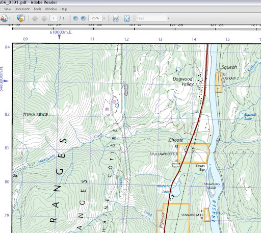
Looking at those maps from the mountains near Hope, B.C., there is perhaps one significant failing of the newer maps - the contour elevations are not as easily interpreted. The CanMatrix versions show the contour elevations for the major contours (see the 4000 contour near Zofka Ridge in the upper left) but the CanTopo versions don't present the information in the same way. Actually, after looking more closely at the full map in regions not pictured, they do seem to offer at least one contour elevation for every hill or mountain allowing you to count and extrapolate the rest of the contours from there. It's omitted from these screenshots because I snipped from the corner of the map. Luckily, this is a matter of only small importance where I typically travel in the wilderness.
No comments:
Post a Comment